
Geotechnical investigations form the foundation of successful construction projects by revealing the hidden characteristics of soil and rock beneath a site. Whether planning a commercial building, residential development, highway expansion, or industrial facility, understanding subsurface conditions prevents costly surprises and ensures structural integrity. These systematic studies combine field exploration, laboratory analysis, and engineering interpretation to deliver actionable data that shapes project design, construction methods, and long-term performance expectations across Alberta's diverse geological landscape.
Understanding the Purpose of Geotechnical Investigations
Every construction project relies on the ground beneath it, yet subsurface conditions remain invisible until properly investigated. Geotechnical investigations provide essential data about soil composition, bearing capacity, groundwater levels, and potential hazards that influence foundation design and construction planning.
These studies serve multiple critical functions beyond basic soil testing. Engineers use investigation results to determine appropriate foundation types, whether shallow footings, deep piles, or specialized systems. The data also reveals potential challenges such as expansive clays, collapsible soils, high water tables, or contamination that require mitigation strategies before construction begins.
Risk Mitigation Through Proper Investigation
Financial risks escalate dramatically when projects proceed without adequate subsurface knowledge. Unexpected soil conditions discovered during construction lead to design changes, schedule delays, and budget overruns that often exceed the cost of thorough initial investigations by significant margins.
Key risks addressed through geotechnical investigations include:
- Foundation settlement or bearing capacity failures
- Slope instability and landslide potential
- Groundwater intrusion into excavations
- Soil liquefaction in seismic zones
- Corrosive soil impacts on buried infrastructure
- Frost heave in cold climates
Alberta's geology presents unique challenges that make comprehensive investigations particularly valuable. The region features variable glacial deposits, expansive clay formations, and seasonal frost penetration that demand site-specific analysis rather than assumptions based on nearby projects.
Planning and Executing Field Investigations
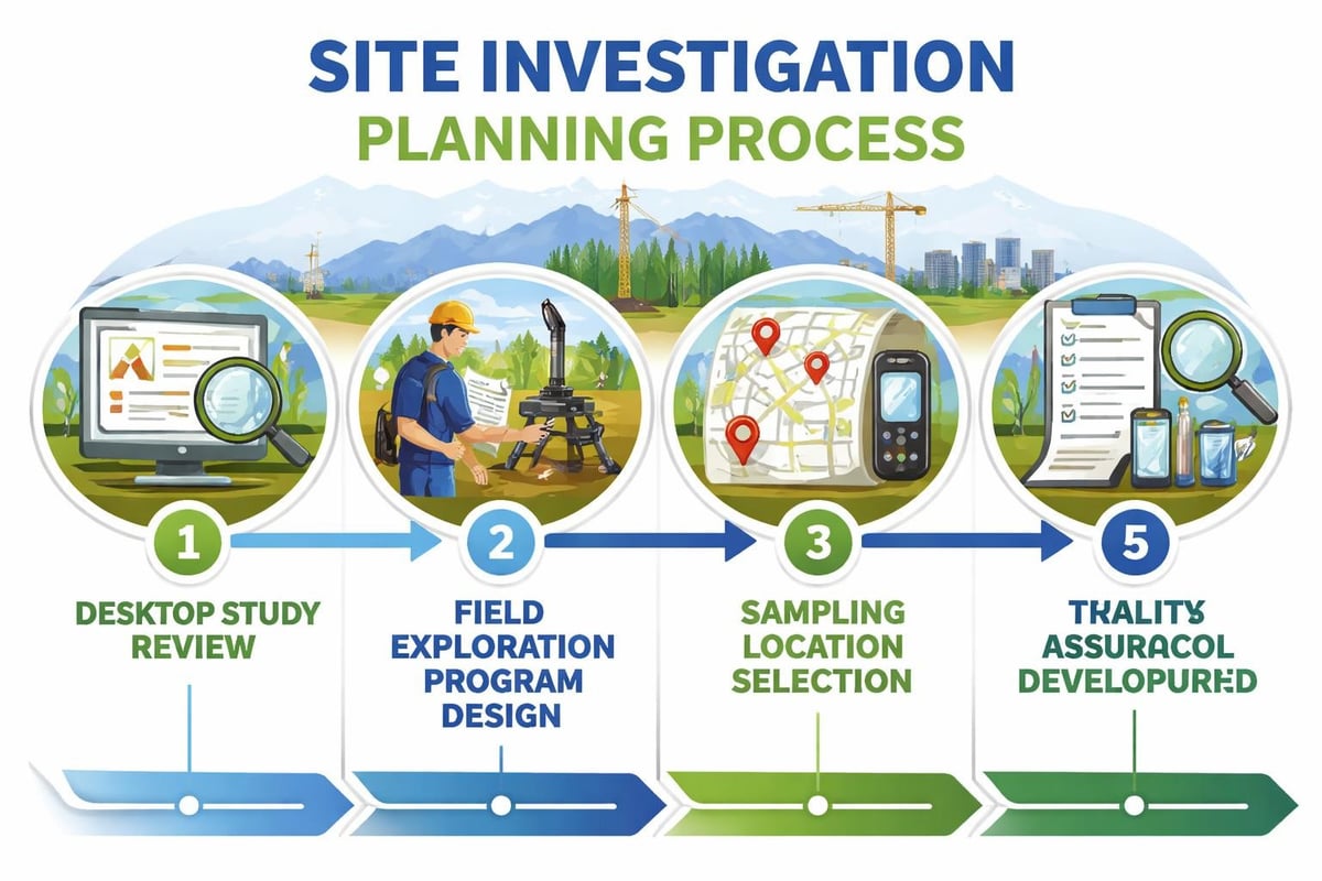
Successful geotechnical investigations begin with thorough planning that aligns exploration methods with project requirements and site characteristics. The investigation scope varies significantly between a single-family home and a multi-story commercial building, requiring scaled approaches that balance thoroughness with budget constraints.
Desktop Studies and Preliminary Assessment
Before mobilizing field equipment, experienced geotechnical engineers conduct desktop studies using existing geological maps, historical reports, aerial imagery, and regional soil databases. This preliminary research identifies potential concerns, guides exploration locations, and optimizes field investigation efficiency.
According to comprehensive guidelines on geotechnical investigations, the desktop phase should review previous site uses, groundwater records, seismic hazard maps, and any available subsurface information from adjacent properties. This foundation knowledge prevents redundant testing while highlighting areas requiring focused attention.
Field Exploration Methods
Multiple exploration techniques combine to create a complete subsurface profile. Test pit excavations provide direct visual examination of soil layers in the upper 4-6 meters, allowing engineers to observe stratification, moisture conditions, and rootzone characteristics firsthand.
Drilling methods commonly employed in Alberta include:
- Hollow stem auger drilling for continuous soil sampling in cohesive and granular materials
- Direct push technology for rapid profiling and groundwater sampling
- Rotary wash boring for deeper investigations and rock coring
- Sonic drilling for challenging materials and minimal soil disturbance
Each drilling method produces different sample qualities and suits specific soil conditions. The National Academies publication on geotechnical site investigations provides detailed guidance on selecting appropriate exploration techniques for underground projects and complex geological settings.
| Exploration Method | Typical Depth Range | Sample Quality | Best Applications |
|---|---|---|---|
| Test Pits | 0-6 meters | Excellent (bulk) | Shallow foundations, visual inspection |
| Hollow Stem Auger | 3-30 meters | Good to excellent | Standard penetration testing, continuous sampling |
| Direct Push | 0-15 meters | Fair to good | Environmental screening, groundwater monitoring |
| Rotary Drilling | 15-100+ meters | Variable | Rock coring, deep foundations, bedrock mapping |
Sampling procedures follow standardized protocols to ensure representative specimens reach the laboratory for testing. Undisturbed samples preserve natural soil structure for compression testing and consolidation analysis, while disturbed samples suffice for classification and basic property determination.
Laboratory Testing Programs
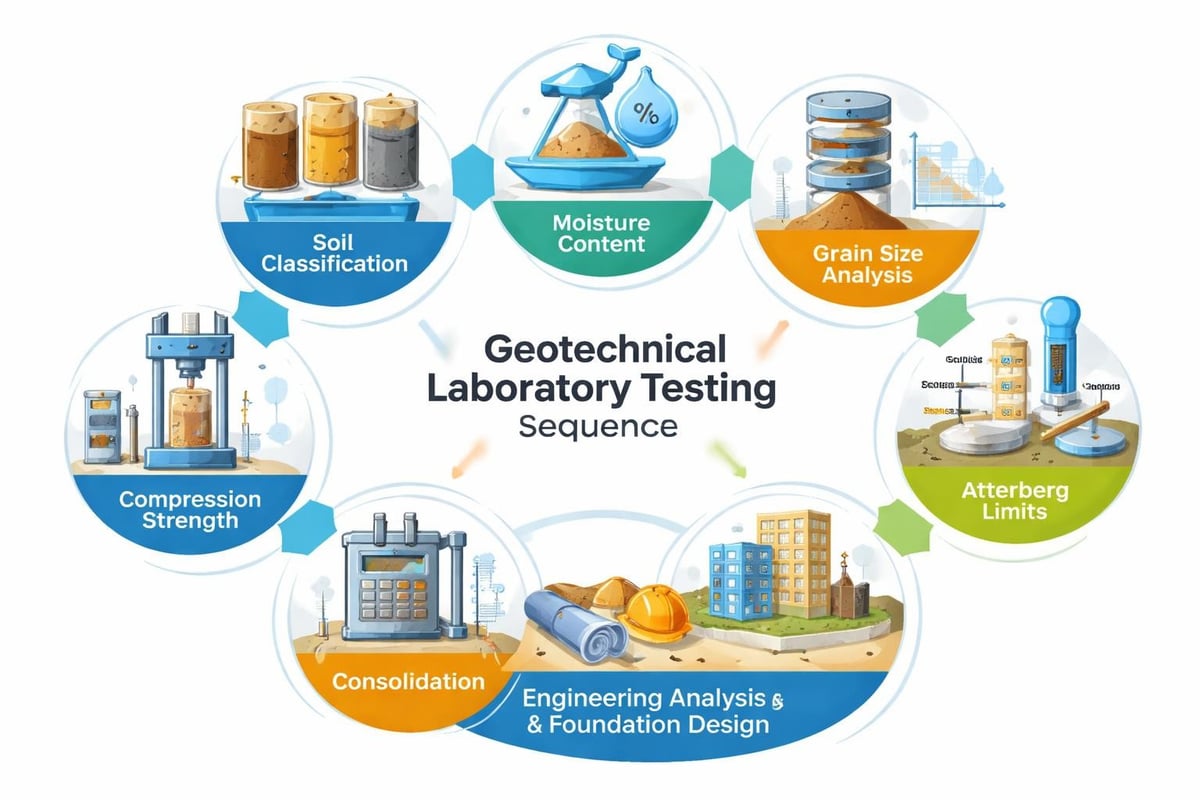
Raw soil and rock samples hold limited value until laboratory analysis quantifies their engineering properties. Testing programs transform field specimens into numerical data that engineers use for calculations, modeling, and design decisions.
Classification and Index Properties
Initial laboratory work focuses on classifying soils according to standardized systems. Grain size distribution analysis separates soil particles through sieve and hydrometer testing, determining percentages of gravel, sand, silt, and clay. Atterberg limits testing measures plasticity characteristics that influence soil behavior under varying moisture conditions.
Natural moisture content, unit weight, and specific gravity provide baseline index properties. These fundamental measurements appear simple but offer powerful insights into soil consistency, compaction state, and likely engineering behavior across the project site.
Strength and Consolidation Testing
Foundation design requires quantified strength parameters that predict soil performance under structural loads. Unconfined compression testing measures cohesive soil strength, while triaxial shear testing determines friction angle and cohesion under controlled stress conditions.
For projects involving significant loading or soft clay layers, consolidation testing predicts settlement magnitude and time-dependent behavior. These tests subject soil specimens to incremental loads while monitoring compression over days or weeks, providing data essential for settlement calculations and foundation design optimization.
The Canadian Geotechnical Journal regularly publishes research on testing methodologies and interpretation techniques applicable to Canadian soil conditions, offering valuable insights for practitioners working across Alberta's varied geological environments.
Specialized Testing Requirements
Complex projects or unusual soil conditions demand specialized testing beyond standard protocols. Corrosion potential testing evaluates soil chemistry and resistivity to assess risks for buried steel, concrete, or other materials. Permeability testing measures hydraulic conductivity for drainage design and dewatering planning.
Chemical testing becomes essential when investigating sites with potential contamination or aggressive groundwater conditions. Parameters including pH, sulfate content, and chloride concentration help engineers specify appropriate concrete mixes and protective coatings for long-term durability.
Interpreting Results and Engineering Analysis
Laboratory data and field observations converge during the interpretation phase, where geotechnical engineers transform raw information into practical design recommendations. This analytical process requires both technical expertise and judgment based on experience with regional soil behavior.
Subsurface Profile Development
Engineers synthesize borehole logs, test results, and geological knowledge to create subsurface profiles showing soil layer thickness, properties, and variability across the site. These profiles identify critical layers such as weak clay deposits, liquefiable sands, or shallow bedrock that control foundation options.
Groundwater conditions receive particular attention because water levels influence bearing capacity, excavation methods, and long-term foundation performance. Seasonal fluctuations, artesian conditions, and perched water tables complicate analysis and often require monitoring over extended periods for accurate characterization.
Foundation Recommendations and Design Parameters
Investigation findings directly inform foundation type selection and design parameters. Shallow foundations prove economical and practical when competent soil exists at reasonable depth, while weak surface soils or high loads necessitate deep foundations extending to stronger strata.
Engineers calculate allowable bearing pressures, settlement estimates, and lateral earth pressures based on tested soil properties. Safety factors appropriate to soil variability, testing quality, and structure importance protect against uncertainties inherent in subsurface conditions.
For projects requiring specialized deep foundation piles, geotechnical investigations determine pile length requirements, installation methods, and expected capacities. The investigation scope often includes load testing recommendations to verify design assumptions during construction.
Regulatory Standards and Best Practices
Geotechnical investigations conducted across Alberta must adhere to recognized standards that ensure quality, consistency, and professional competency. These frameworks protect public safety while providing clear expectations for engineers, contractors, and project owners.
Canadian Foundation Engineering Manual
The Canadian Geotechnical Society's foundation engineering manual serves as the primary reference for investigation scope, testing procedures, and design methodologies across Canada. This comprehensive resource addresses regional considerations including frost action, permafrost, and seismic design specific to Canadian conditions.
International standards also influence Alberta practice. The British code BS 5930 offers detailed guidance on site investigation planning and execution, while Eurocode 7 provides European perspectives on geotechnical design principles that complement Canadian approaches.
Professional Responsibility and Certification
Licensed professional engineers must sign and seal geotechnical reports in Alberta, accepting legal responsibility for investigation quality and recommendation accuracy. This professional oversight ensures investigations meet minimum standards while holding practitioners accountable for their work.
Field and laboratory technicians require appropriate training and certification to perform testing according to standardized methods. Quality assurance programs verify equipment calibration, procedure compliance, and result reliability throughout the investigation process.
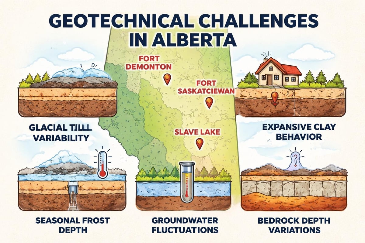
Regional Considerations for Alberta Projects
Alberta's geological diversity demands investigation approaches tailored to specific regional characteristics. Glacial history, bedrock geology, climate, and groundwater conditions vary significantly between Edmonton, Fort Saskatchewan, Slave Lake, and southern Alberta locations.
Glacial Deposits and Till Composition
Much of Alberta sits atop glacial deposits featuring variable till compositions, lacustrine clays, and outwash sands. These deposits exhibit erratic properties both vertically and horizontally, making interpolation between boreholes challenging and requiring adequate exploration density for reliable characterization.
Clay till dominates many areas, presenting moderate strength when dry but losing capacity rapidly with increased moisture content. Investigation programs must assess moisture sensitivity and evaluate long-term performance under varying groundwater conditions.
Seasonal Frost and Climate Impacts
Alberta's cold climate produces frost penetration depths reaching 1.5 to 2.5 meters depending on location and winter severity. Foundations must extend below frost depth to prevent heave damage, and pavement designs must accommodate freeze-thaw cycles that break down certain soil types.
Geotechnical investigations evaluate frost susceptibility through grain size analysis and moisture content assessment. Highly frost-susceptible soils may require removal, insulation, or drainage improvements to ensure satisfactory long-term performance.
Common Investigation Challenges and Solutions
Even well-planned geotechnical investigations encounter obstacles that require adaptation and problem-solving during execution. Recognizing common challenges helps project teams maintain schedule and budget while achieving investigation objectives.
Access Limitations and Site Constraints
Existing structures, utilities, vegetation, and property boundaries often restrict drilling locations, forcing compromises between ideal investigation points and practical accessibility. Urban sites present particular challenges with underground services requiring careful clearance procedures before drilling.
Creative solutions include:
- Angled drilling to reach beneath structures
- Hand auger techniques in confined spaces
- Geophysical methods to supplement direct exploration
- Coordination with utility locators and property owners
Difficult Drilling Conditions
Certain geological conditions challenge conventional drilling methods. Cobbles and boulders deflect drilling tools, creating incomplete penetration or preventing sample recovery. Artesian conditions cause borehole instability and groundwater surges that complicate sampling.
Experienced drilling contractors maintain diverse equipment capable of adapting to challenging conditions. When standard methods fail, alternative approaches such as rotary drilling, casing advancement, or probe holes provide necessary subsurface information despite difficult materials.
Budget and Scope Optimization
Limited budgets tempt project owners to minimize investigation scope, risking inadequate subsurface characterization. Professional engineers balance cost constraints against technical needs, recommending minimum investigation programs that provide essential data while acknowledging uncertainty levels.
Phased investigations offer a strategic approach for large or complex projects. Initial reconnaissance drilling identifies major concerns and refines understanding, followed by targeted supplemental investigations addressing specific design questions. This staged methodology controls costs while ensuring adequate information for critical decisions.
Integration with Environmental Assessments
Many projects require both geotechnical and environmental investigations, creating opportunities for coordination that improves efficiency and data quality. Combined programs share mobilization costs, drilling activities, and site access while addressing both subsurface engineering and contamination concerns.
Environmental Phase I, II, and III assessments often involve soil and groundwater sampling that complements geotechnical programs. Coordination ensures sampling depths, locations, and procedures meet both environmental and engineering requirements without redundant effort or cost.
Environmental concerns sometimes emerge during geotechnical drilling through odors, staining, or unexpected materials encountered in boreholes. Proper communication between geotechnical and environmental teams allows prompt investigation of potential contamination while maintaining worker safety and regulatory compliance.
Quality Assurance and Reporting Standards
Reliable investigation results depend on rigorous quality control throughout field and laboratory phases. Systematic procedures verify equipment calibration, sample handling, testing accuracy, and data recording at each step from drilling through final reporting.
Field Quality Control
Drilling logs must accurately describe encountered materials, sampling depths, groundwater observations, and any unusual conditions. Experienced geotechnical professionals supervise drilling operations, ensuring proper sampling techniques and immediate documentation of field observations.
Sample handling protocols preserve specimen integrity during transportation and storage. Chain of custody procedures track samples from collection through testing, preventing mix-ups and ensuring traceability for critical design decisions.
Laboratory Quality Systems
Accredited geotechnical laboratories maintain quality management systems complying with ISO 17025 or equivalent standards. Regular proficiency testing, equipment calibration, and procedure audits verify testing accuracy and consistency.
Test result review by qualified engineers catches anomalies, inconsistencies, or values requiring confirmation testing. This professional oversight prevents design decisions based on erroneous data while building confidence in investigation findings.
Comprehensive Reporting
Geotechnical reports synthesize all investigation components into coherent documents supporting design and construction decisions. Effective reports include:
- Executive summary highlighting key findings and recommendations
- Site description and geological setting
- Field investigation methodology and exploration logs
- Laboratory testing program and detailed results
- Subsurface profile interpretations
- Foundation design recommendations and parameters
- Construction considerations and monitoring requirements
Clear, concise writing makes technical information accessible to project stakeholders with varying backgrounds. Graphics, tables, and cross-sections enhance understanding while presenting complex subsurface conditions in digestible formats.
Applications Across Project Types
Geotechnical investigations serve diverse project categories, each presenting unique technical requirements and investigation focuses. Understanding these variations helps tailor investigation programs to specific project needs and performance expectations.
Residential Development
Single-family homes require focused investigations assessing shallow foundation suitability, basement construction feasibility, and site grading considerations. While less extensive than commercial projects, residential investigations still demand professional thoroughness protecting homeowner investments.
Multi-family developments and subdivision projects benefit from systematic investigation programs covering the entire development area. Strategic boring layouts identify property-wide patterns while allowing lot-specific recommendations for varying soil conditions across large sites.
Commercial and Industrial Facilities
Larger structures carrying significant loads require comprehensive investigations supporting detailed foundation engineering. Multiple boreholes at column locations, laboratory testing programs characterizing strength and compressibility, and settlement analysis ensure economical foundation designs meeting strict performance criteria.
Industrial facilities often add specialized concerns including heavy equipment vibrations, chemical storage risks, and large floor slab requirements. Investigation programs address these unique demands through targeted testing and analysis beyond standard procedures.
Infrastructure Projects
Highway construction, pipeline installations, and utility corridors demand linear investigations covering extended alignments through varying terrain and geology. The Federal Energy Regulatory Commission guidelines outline investigation procedures for infrastructure projects, emphasizing systematic exploration along proposed routes.
Bridge foundations require detailed investigations at pier locations, assessing deep soil conditions and rock characteristics supporting large concentrated loads. Scour potential, seismic considerations, and long-term durability influence foundation type selection and design parameters for critical transportation structures.
Geotechnical investigations provide the essential foundation knowledge that transforms construction projects from risky ventures into engineered successes backed by quantified subsurface understanding. From initial desktop studies through final design recommendations, systematic investigation, testing, and analysis deliver the confidence needed for informed decisions throughout project lifecycles. Whether planning residential developments, commercial facilities, or infrastructure improvements across Alberta, ZALIG Consulting Ltd offers comprehensive geotechnical engineering services combining field expertise, laboratory capabilities, and professional engineering analysis. Contact their Edmonton, Fort Saskatchewan, or Slave Lake offices to discuss how tailored investigation programs can support your next project with reliable subsurface data and actionable recommendations.