
As infrastructure and construction projects ramp up for 2026, the need for a thorough geotechnical investigation has never been more urgent. Without a clear understanding of ground conditions, costly setbacks and design failures can threaten even the most promising projects.
This guide demystifies the geotechnical investigation process, offering actionable insights for project managers, engineers, and stakeholders. You will learn the fundamentals, step-by-step investigation process, modern testing methods, regulatory trends, and how to leverage data for risk mitigation.
Stay ahead of challenges by equipping yourself with expert-backed guidance that can help ensure project success and avoid costly errors.
The Fundamentals of Geotechnical Investigation
Understanding the fundamentals of geotechnical investigation is essential for any successful infrastructure project. As 2026 approaches, the need for thorough site assessment has never been more urgent. This section breaks down what a geotechnical investigation is, its core steps, who is involved, typical timelines and costs, and the major risks of overlooking this critical process.
What is Geotechnical Investigation?
A geotechnical investigation is a systematic process used to assess the physical properties of soil, rock, and groundwater at a project site. The primary goal is to gather essential data for the safe and cost-effective design of structures such as buildings, roads, and bridges.
For 2026 projects, geotechnical investigation is the foundation for sustainable and resilient infrastructure. It helps project teams identify and mitigate risks like settlement, liquefaction, or slope failure before construction begins. One notable example involved a bridge foundation failure traced back to inadequate site investigation, resulting in costly delays and redesigns.
By conducting a thorough geotechnical investigation, teams can comply with building codes, inform design choices, and minimize surprises during construction.
Core Components of a Geotechnical Study
A comprehensive geotechnical investigation involves several key steps:
- Literature review and analysis of historical site data
- Site reconnaissance and surface mapping
- Subsurface exploration using borings, test pits, or geophysical methods
- Collection of soil and rock samples for laboratory analysis
- Detailed reporting with recommendations for design and construction
Each component builds on the last, ensuring that no aspect of the site’s behavior is left to chance. For a deeper look at the typical steps and their significance, see this overview of the Geotechnical Site Investigation Process.
By following a structured approach, teams can anticipate challenges and provide tailored solutions for each project's unique conditions.
Stakeholders and Collaboration
Geotechnical investigation is rarely a solo effort. Geotechnical engineers lead the process, but collaboration with geologists, environmental scientists, and civil or structural engineers is vital for comprehensive outcomes.
Successful investigations depend on clear communication between all disciplines. For instance, large freeway projects require geotechnical teams to work closely with designers and environmental consultants to ensure that both technical and regulatory requirements are met.
This multidisciplinary approach not only improves data quality but also streamlines project delivery and reduces the risk of costly missteps.
Typical Project Timeline and Cost Factors
The timeline for a geotechnical investigation typically spans several phases:
| Phase | Activities | Typical Duration |
|---|---|---|
| Feasibility | Desk study, site visit | 1–2 weeks |
| Field Investigation | Drilling, sampling, in situ tests | 2–6 weeks |
| Laboratory Testing | Soil and rock analysis | 1–4 weeks |
| Reporting & Support | Data synthesis, recommendations | 1–3 weeks |
Major projects, such as freeway expansions, may require hundreds of boreholes and tests. For example, an Australian freeway project involved over 360 boreholes. Factors influencing cost include site size, complexity, and regulatory requirements. Early planning and scope definition help manage both timeline and budget.
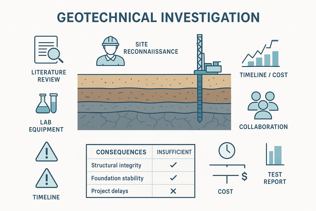
Consequences of Insufficient Investigation
Cutting corners on a geotechnical investigation can have serious consequences:
- Structural failures or foundation issues
- Costly delays and budget overruns
- Environmental damage from unforeseen ground conditions
- Regulatory non-compliance, leading to fines or litigation
For example, unexpected soil conditions have forced major projects into expensive redesigns and schedule setbacks. Inadequate investigation increases liability and can even result in project shutdowns.
Investing in a thorough geotechnical investigation is not just best practice—it is essential for the long-term success and safety of any construction project.
Step-by-Step Geotechnical Investigation Process for 2026 Projects
Understanding the step-by-step process of a geotechnical investigation is essential for successful project delivery in 2026. Each phase builds on the last, ensuring that risks are identified, data is collected, and actionable insights guide every decision. Let’s walk through each stage, highlighting best practices and current trends.
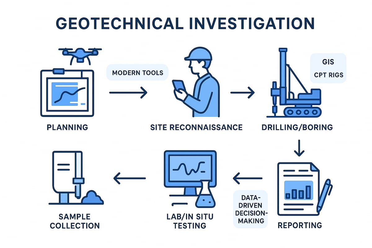
1. Preliminary Assessment and Planning
Every geotechnical investigation begins with a thorough review of existing site data and local geology. Project teams collect historical records, maps, and previous study results to understand the baseline conditions.
Setting clear project objectives and risk thresholds is critical at this stage. The investigation scope is defined based on the type of structure, anticipated loads, and unique site context. For example, a high-rise requires a different scope than a residential building.
Early planning ensures the investigation is targeted, efficient, and aligned with regulatory requirements. This approach saves time and helps avoid costly surprises later in the project.
2. Site Reconnaissance and Surface Exploration
Site reconnaissance provides the first real-world look at existing conditions. Visual inspections, mapping, and hazard identification form the backbone of this step.
Modern tools such as drones, GIS, and photogrammetry allow teams to cover large or complex sites efficiently. These technologies can reveal features like drainage paths, surface instability, or landslide-prone areas that might not be visible at ground level.
By combining traditional observation with advanced technology, the geotechnical investigation process identifies potential risks early and informs the next phases of work.
3. Subsurface Exploration Techniques
Subsurface exploration is the heart of any geotechnical investigation. Engineers select drilling methods such as borings (large or small diameter), test pits, or trenches based on site requirements and expected soil types.
Geophysical methods add valuable data. Techniques like seismic refraction, electrical resistivity, and electromagnetic surveys allow for non-intrusive profiling of the subsurface. For offshore or deepwater projects, specialized rigs and techniques are needed due to access and stability challenges.
Data from methods like MASW and SASW provide rapid, non-destructive profiles, helping engineers build accurate subsurface models. This stage ensures that enough information is available for sound engineering decisions.
4. Soil and Rock Sampling Methods
Collecting quality samples is crucial for a reliable geotechnical investigation. Both disturbed and undisturbed samples are taken, each serving different analytical needs.
Sampling tools include split-spoon samplers, Shelby tubes, piston samplers, and augers. Standards like ASTM D1586 for Standard Penetration Test, D1587 for thin-walled tubes, and D2113 for rock coring ensure consistency and reliability.
For foundation design, SPT blow counts are often used to estimate soil strength and behavior. Accurate sampling underpins every recommendation made in the final report.
5. Laboratory Testing and In Situ Tests
Once samples are collected, they undergo rigorous laboratory and in situ testing. Laboratory index tests measure grain size, Atterberg limits, and moisture content, while strength and stiffness are assessed through triaxial and direct shear tests.
In situ methods such as the Standard Penetration Test (SPT), Cone Penetration Test (CPT), Dilatometer Test (DMT), and seismic CPT provide real-time data directly from the field. For more on these critical methods, see In Situ Geotechnical Testing Methods.
Combining laboratory and field data allows engineers to develop accurate models for design and risk mitigation, ensuring the geotechnical investigation delivers actionable results.
6. Data Synthesis and Reporting
The final stage of a geotechnical investigation involves synthesizing all collected data. Engineers interpret field and laboratory results to develop geotechnical models tailored to the project’s needs.
Comprehensive reports are produced for design, permitting, and construction support. These documents often evolve as new data emerges or as the design progresses, ensuring recommendations stay relevant.
Effective reporting translates technical findings into clear, actionable guidance, supporting safe, cost-effective, and resilient infrastructure for 2026 and beyond.
Modern Testing Methods and Technologies Shaping 2026 Investigations
As project timelines tighten and complexity rises, modern testing methods are redefining geotechnical investigation for 2026 projects. Innovations in field, laboratory, and digital technologies are enabling more accurate, rapid, and cost-effective site characterization. Embracing these advancements is essential for project managers and engineers seeking to minimize risk and maximize value.
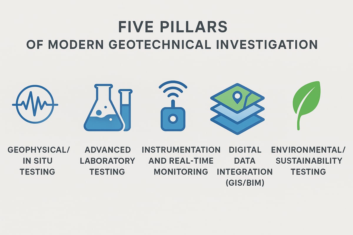
Advances in Geophysical and In Situ Testing
Geophysical and in situ testing methods are transforming how subsurface conditions are mapped and understood. Multichannel and spectral surface wave analysis (MASW, SASW) allow engineers to rapidly profile soil stiffness across large areas. Seismic, magnetic, and electrical resistivity imaging techniques provide non-destructive, three-dimensional insights into the ground.
For complex or sensitive sites, seismic cone penetration testing (CPT) and seismic dilatometer tests (SDMT) offer detailed shear wave velocity data. These approaches make a geotechnical investigation more comprehensive by pinpointing hidden hazards and variability. For example, using MASW on a proposed highway alignment can reveal buried weak layers that might otherwise go undetected.
Engineers benefit from faster decision-making, reduced uncertainty, and the ability to adapt designs early in the project lifecycle.
Laboratory Innovations and Physical Modeling
Laboratory testing has evolved with the introduction of automated equipment, enabling quicker and more precise analysis of soil and rock samples. This advance is critical for large infrastructure projects where turnaround time is crucial. Physical modeling, including centrifuge techniques, helps simulate how soil and structures interact under real-world conditions.
Despite their strengths, these methods have limitations, such as sample size and boundary effects. Large-scale embankment modeling, for instance, provides valuable data but may not capture every field variable. To explore the range of laboratory techniques available for geotechnical investigation, visit Advanced Geotechnical Laboratory Testing.
Combining automated testing and scaled physical modeling supports more reliable designs and better risk management.
Instrumentation and Real-Time Monitoring
Instrumentation is now at the forefront of geotechnical investigation, with embedded sensors placed in the ground to monitor pore pressure, settlement, and deformation. These sensors relay real-time data to cloud-based platforms, allowing project teams to detect issues as soon as they arise.
Remote data acquisition means that even sites in remote or hazardous locations can be monitored continuously. This capability improves construction control, reduces the likelihood of unexpected ground movement, and enables early warning for safety-critical situations.
The integration of real-time monitoring into geotechnical investigation strategies enhances both safety and cost efficiency for 2026 projects.
Digital Data Integration and BIM
Digital transformation is revolutionizing how geotechnical investigation data is managed and shared. Geographic Information Systems (GIS) and Building Information Modeling (BIM) are now used to compile, visualize, and analyze subsurface data alongside design models.
For example, integrating borehole logs and geophysical survey data directly into a BIM environment streamlines collaboration among engineers, architects, and contractors. This approach optimizes design choices, reduces errors, and enables more effective project delivery.
By embedding geotechnical investigation insights into the digital project workflow, teams can make smarter, data-driven decisions throughout design and construction.
Environmental and Sustainability Considerations
Today's geotechnical investigation must also address environmental and sustainability goals. Modern testing now includes assessments of soil contamination, permeability, and groundwater flow to ensure projects meet regulatory and ecological standards.
Sustainable investigation practices, such as targeted sampling and minimal-impact drilling, are increasingly prioritized. For projects like solar thermal storage or radioactive waste disposal, evaluating geotechnical suitability is essential for long-term safety and performance.
By integrating environmental criteria into the geotechnical investigation process, project teams support both regulatory compliance and broader sustainability objectives.
Regulatory Trends and Standards Impacting 2026 Geotechnical Investigations
As 2026 approaches, regulatory frameworks for geotechnical investigation are rapidly evolving. Staying ahead of these changes is crucial for compliance, risk reduction, and project success. Let’s explore the current landscape and what project teams need to know.
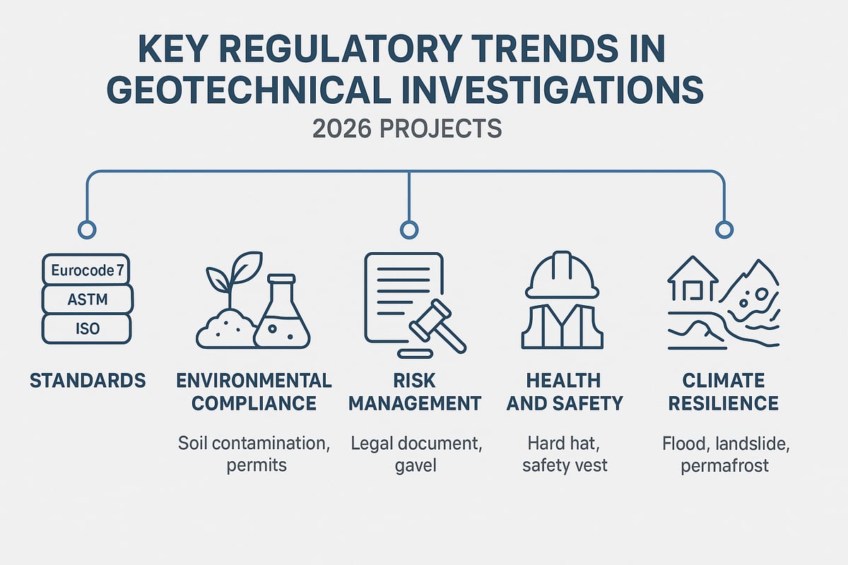
Evolving Codes and Best Practices
Global standards for geotechnical investigation, such as Eurocode 7, ASTM, ISO, and regional codes, are being updated to match new industry expectations. The focus is on higher data quality, traceability, and digital reporting. For example, Annex B.3 of Eurocode 7 now details requirements for investigation spacing and depth. In many regions, digital submission of geotechnical investigation data is mandatory. Consistency in test reporting is emphasized, especially for in situ tests. For more on standardizing results, see this Correlation Between CPT and SPT resource.
Environmental Regulations and Compliance
Environmental oversight is intensifying in geotechnical investigation, especially for large infrastructure projects. Regulations now require comprehensive contamination assessments and groundwater analysis before permitting. Environmental site assessments are often mandatory, ensuring that soil and groundwater risks are identified early. This process helps protect communities and ecosystems, while also streamlining project approvals. Project managers should anticipate stricter documentation and remediation requirements as part of the geotechnical investigation workflow.
Risk Management and Liability
Documentation standards are tightening, making robust records vital for every geotechnical investigation. Detailed logs, transparent methodologies, and clear recommendations are essential for defending against litigation. Peer review and engineering judgment are increasingly required by regulatory bodies. Legal cases have shown that insufficient geotechnical investigation can lead to foundation failures and costly disputes. Proactive risk management, with full traceability, reduces exposure and builds confidence with stakeholders.
Health, Safety, and Accessibility
Health and safety protocols are central to modern geotechnical investigation. New regulations require strict procedures for drilling, sampling, and working in confined spaces. Accessibility is also a growing concern, especially in dense urban or remote environments. Offshore investigations demand specialized vessels, equipment, and safety training. Adhering to these standards not only protects workers but also ensures that projects remain on schedule and avoid regulatory penalties.
Future-Proofing for Climate and Resilience
Climate change is reshaping geotechnical investigation standards worldwide. Updated codes require consideration of flood risk, permafrost thaw, and increased landslide potential. Investigations must now address resilience, ensuring that foundations and earthworks can withstand extreme events. Incorporating climate adaptation strategies at the site characterization stage is becoming standard practice, helping safeguard infrastructure and communities for decades to come.
Leveraging Geotechnical Data for Design, Risk Mitigation, and Project Success
Effectively using data from a geotechnical investigation can transform the success of any major infrastructure project. By converting test results into actionable insights, teams can make informed choices that impact design, safety, costs, and long-term performance.
Translating Data into Design Parameters
A comprehensive geotechnical investigation supplies critical parameters for every stage of design. Test results such as soil strength, compressibility, and settlement potential are correlated to engineering properties that guide foundation sizing, slope stability, and earthworks.
For example, Standard Penetration Test (SPT) N-values and Cone penetration test (CPT) resistance are directly linked to allowable bearing pressures and pile design. Engineers use these values to choose appropriate foundation types and dimensions, ensuring structures are both safe and cost-efficient.
Laboratory tests like the Triaxial shear test further inform design by defining how soils will behave under load. With accurate data, designs can be optimized for specific site conditions, reducing the risk of overdesign or unexpected failures.
Identifying and Mitigating Site Risks
Every geotechnical investigation is an opportunity to uncover and address site hazards before construction begins. Early detection of risks such as liquefaction, expansive soils, or sinkholes allows for proactive planning.
Common strategies include:
- Ground improvement (e.g., compaction, grouting, soil stabilization)
- Selecting deeper or alternative foundation systems
- Implementing drainage or dewatering solutions
By integrating risk mitigation into the design phase, costly delays and redesigns can be avoided. This process not only protects the project timeline but also ensures compliance with codes and regulatory standards.
Optimizing Construction Methods and Costs
Accurate geotechnical investigation data empowers project teams to match construction methods to site realities. This alignment avoids unnecessary contingencies and minimizes both material and labor costs.
For instance, knowing the exact soil profile enables engineers to select between shallow and deep foundations or to tailor pile lengths and types. This reduces waste and shortens construction schedules.
Key benefits include:
- Fewer change orders and unexpected site issues
- Streamlined construction sequencing
- More predictable budgets and timelines
Investing in a thorough geotechnical investigation pays dividends throughout the project lifecycle.
Enhancing Sustainability and Lifecycle Performance
Modern infrastructure demands sustainable solutions, and geotechnical investigation data is central to meeting these goals. By understanding site-specific conditions, engineers can design for durability, adaptability, and minimal environmental impact.
Examples of sustainable practices:
- Targeted site investigations to limit disturbance
- Designing for efficient drainage and erosion control
- Reusing or improving on-site materials for earthworks
Lifecycle assessments, informed by geotechnical data, help ensure that structures remain safe and serviceable under changing conditions, including climate-related impacts.
Case Studies: Lessons from Recent Projects
Recent large-scale projects highlight the value of comprehensive geotechnical investigation. On a major Australian freeway, more than 360 boreholes and over 120 cone tests were performed. This phased approach enabled iterative updates to the geotechnical model, supporting design adjustments as new data emerged.
Key takeaways include:
- Early and ongoing data collection reduces the risk of costly surprises
- Integrated teams improve collaboration and decision-making
- Detailed documentation supports regulatory compliance and future maintenance
By leveraging geotechnical investigation data throughout the project, stakeholders can achieve safer, more efficient, and resilient infrastructure.
Choosing the Right Geotechnical Partner for 2026 Projects
Selecting the right partner for your geotechnical investigation is a critical first step for any 2026 infrastructure project. The expertise and approach of your consulting firm can determine whether your project proceeds smoothly or faces costly setbacks. By focusing on a firm’s qualifications, service range, and commitment to client needs, you set the stage for success.
Qualities of a Top-Tier Geotechnical Consulting Firm
A top-tier partner brings specialized knowledge, regional insight, and a proven record of reliable geotechnical investigation. Look for firms with:
- In-house expertise: Geotechnical, environmental, and material testing professionals.
- Innovation: Adoption of advanced field and laboratory methods.
- Reliability: Consistent project delivery, adherence to standards, and safety protocols.
- Local presence: Offices or teams familiar with your project’s geographic and regulatory context.
For example, firms leading large-scale infrastructure projects often maintain multiple offices across project regions, ensuring rapid response and deep understanding of local site conditions. This regional presence supports efficient geotechnical investigation, timely reporting, and cost-effective solutions.
Service Offerings and Capabilities to Look For
The range and depth of a firm’s services are crucial for a successful geotechnical investigation. Comprehensive offerings should include:
- Site investigation: Surface and subsurface exploration tailored to project needs.
- Laboratory and field testing: Soil, rock, and groundwater analysis using industry standards.
- Environmental assessments: Identification and mitigation of site hazards.
- Design support: Integration with civil, structural, and transportation engineering.
Quality assurance systems and relevant certifications (such as ISO or ASTM) are also vital, ensuring that every geotechnical investigation meets regulatory and industry benchmarks. Multidisciplinary integration allows for seamless collaboration across project phases, enabling efficient problem-solving and risk management.
Client-Centric Approach and Project Management
A client-focused firm tailors its geotechnical investigation processes to the unique needs of each project. Key aspects include:
- Customized solutions: Adaptation for public, industrial, or private sector requirements.
- Lean project management: Efficient workflows, clear communication, and proactive issue resolution.
- Strong relationships: Partnerships with municipalities, school boards, or industrial clients.
Effective geotechnical investigation partners prioritize transparency, regular updates, and flexibility as designs evolve. Their commitment to client satisfaction ensures that every challenge is addressed promptly, supporting project objectives and reducing delays.
Article written using RankPill.