
Borehole drilling represents one of the most critical subsurface investigation techniques used across civil infrastructure, environmental assessment, and resource exploration projects. This specialized drilling process creates narrow, deep holes in the ground to collect soil and rock samples, install monitoring equipment, access groundwater, and gather essential data for engineering design and regulatory compliance. From small-diameter geotechnical test holes to deep water wells and environmental monitoring installations, borehole drilling provides the foundational data that informs site development decisions, risk assessment, and construction planning. Understanding the methodology, applications, and regulatory requirements of borehole drilling enables project teams to gather defensible subsurface information while managing costs, timelines, and compliance obligations.
Understanding Borehole Drilling Methods and Applications
Borehole drilling encompasses various techniques selected based on soil conditions, required depth, sample quality needs, and project objectives. The drilling method directly impacts data quality, field time, and overall investigation costs.
Rotary Drilling Techniques
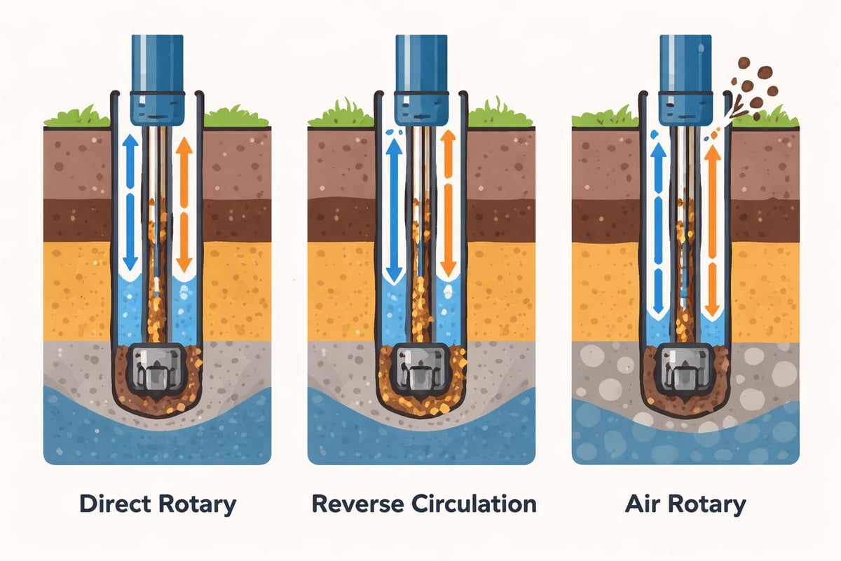
Rotary drilling methods use continuous rotation of drill bits to advance through soil and rock formations. Direct rotary drilling pumps drilling fluid (mud) down through the drill string and back up the annular space, cooling the bit and carrying cuttings to the surface. This method excels in soft to medium formations and allows for relatively fast advancement.
Reverse circulation rotary drilling operates with fluid flow in the opposite direction, moving up through the drill string rather than the annulus. This technique provides better sample recovery in unconsolidated formations and reduces the risk of cross-contamination between aquifer zones.
Air rotary drilling substitutes compressed air for drilling fluid, making it ideal for water well installation and situations where introducing fluids could compromise sample chemistry or hydrogeological conditions. The USGS has documented extensive borehole data collection using various rotary methods in complex geological settings.
Percussion and Cable Tool Methods
Cable tool drilling, one of the oldest borehole drilling techniques, uses repeated impact from a heavy cutting bit suspended on a cable. The bit breaks up formation material, which is periodically removed using a bailer. While slower than rotary methods, cable tool drilling provides excellent sample quality in consolidated formations and avoids introducing foreign fluids.
Sonic drilling combines high-frequency vibration with rotation to advance a core barrel through varied subsurface conditions. This method delivers continuous, relatively undisturbed core samples and works effectively across soil types from clay to cobbles, though equipment costs typically exceed conventional methods.
Auger Drilling Applications
Hollow-stem auger drilling dominates shallow geotechnical investigations and environmental sampling programs. The continuous flight auger advances through soil while the hollow center allows insertion of sampling tools without withdrawing the auger string. This configuration maintains borehole stability in loose or saturated formations.
Solid-stem augers provide economical advancement for shallow explorations where continuous sampling is unnecessary. The drilling process disturbs formation material significantly, limiting its use to preliminary investigations or installations requiring less stringent sample quality.
| Drilling Method | Typical Depth Range | Best Formation Types | Primary Applications |
|---|---|---|---|
| Hollow-Stem Auger | 0-30 m | Soft to medium soils | Geotechnical sampling, shallow monitoring wells |
| Direct Rotary | 15-300 m | Soft to hard formations | Deep investigations, bedrock coring |
| Cable Tool | 15-150 m | Consolidated formations | Water wells, contaminated site investigations |
| Sonic | 0-75 m | Variable conditions | High-quality continuous sampling |
Planning Borehole Drilling Programs
Effective borehole drilling programs begin with clear objectives tied to specific design questions, regulatory requirements, or risk assessment needs. Poor planning results in inadequate subsurface coverage, sampling gaps, and costly additional fieldwork.
Determining Borehole Locations and Depth
Borehole spacing and depth depend on site variability, structure footprint, loading conditions, and jurisdictional requirements. Geotechnical investigations typically space borings at 15 to 30 meters for building foundations, with depths extending below the anticipated zone of stress influence. Linear infrastructure projects may require borings every 100 to 300 meters depending on subsurface complexity.
Environmental investigations focus borehole placement on suspected source areas, documented historical activities, preferential migration pathways, and compliance point locations. Understanding site history, operations, and conceptual site models guides efficient borehole layouts that characterize contamination extent without excessive drilling.
For water resource development, understanding local hydrogeology, recharge zones, and aquifer characteristics determines optimal borehole locations and target depths. Regional water well databases and geological mapping provide valuable context for planning productive well installations.
Regulatory Considerations and Permitting
Most jurisdictions impose specific requirements on borehole drilling activities, particularly for installations penetrating aquifers or conducted on contaminated properties. Drilling legislation and compliance obligations vary by location but commonly address well construction standards, abandonment procedures, and data reporting.
Key regulatory considerations include:
- Drilling permit applications and approval timelines
- Potable water well setback distances from potential contamination sources
- Proper well construction and sealing requirements
- Decommissioning and abandonment standards for temporary and permanent installations
- Reporting obligations for geological data and water strikes
Environmental borehole drilling on potentially contaminated sites requires additional health and safety protocols, waste characterization, and disposal planning. Drilling fluids, cuttings, and purge water may constitute regulated waste requiring proper handling and documentation.

Borehole Construction and Completion Methods
Proper borehole construction ensures data quality, protects groundwater resources, and provides long-term installation integrity for monitoring or water supply purposes. Construction details vary significantly based on the borehole's intended function and regulatory environment.
Geotechnical Test Borings
Geotechnical borings focus on soil and rock sampling to characterize subsurface conditions for foundation design, slope stability analysis, and earthwork planning. In-situ geotechnical testing within boreholes provides critical strength and deformation parameters that laboratory testing cannot replicate.
Standard penetration testing (SPT) involves driving a split-barrel sampler 450 mm into formation material and recording blow counts, which correlate to soil density and consistency. Undisturbed sampling using thin-walled Shelby tubes preserves soil structure for laboratory consolidation, strength, and permeability testing.
Rock coring recovers cylindrical samples of bedrock for strength testing, discontinuity mapping, and foundation bearing capacity assessment. Core recovery and rock quality designation (RQD) quantify formation quality and integrity.
Monitoring Well Installation
Environmental monitoring wells require careful construction to prevent cross-contamination between aquifer zones while enabling representative groundwater sampling. Typical installation includes:
- Drilling to target depth using methods that minimize formation disturbance
- Installing slotted or screened casing across the zone of interest
- Placing filter pack sand around the screen to prevent fine particle intrusion
- Installing bentonite seals above and below the screened interval
- Grouting the annular space to surface to prevent surface water infiltration
- Installing protective surface completions with secure caps and identification
Well development removes drilling fluids, fines, and residual contamination, establishing hydraulic communication between the aquifer and well screen. Development continues until turbidity decreases and representative formation water enters the well.
Companies offering environmental site assessments rely on properly constructed monitoring wells to gather defensible groundwater quality data supporting risk assessment, regulatory compliance, and remediation planning.
Water Supply Well Construction
Production wells for potable or industrial water supply incorporate larger diameter casings, extended screen lengths, and enhanced development to maximize yield. Well construction follows strict sanitary standards including surface seals, casing materials resistant to corrosion, and grouting practices that prevent contamination.
Pump installation depth, horsepower, and capacity depend on static water level, anticipated drawdown, required flow rate, and total dynamic head. Proper well sizing balances initial construction costs against operational efficiency and long-term reliability.
Sampling Techniques and Data Collection
The value of borehole drilling lies in the quality and representativeness of samples and data collected during and after drilling operations. Systematic sampling protocols ensure recovered material accurately reflects subsurface conditions.
Soil Sampling Standards
Continuous sampling at regular intervals provides comprehensive stratigraphic profiles essential for geotechnical analysis. Common practice specifies sampling at every change in formation and at maximum 1.5-meter intervals in uniform material. Sample depth, recovery, blow counts, and visual descriptions document subsurface variability.
Disturbed samples recovered during drilling advancement support soil classification, moisture content determination, and index property testing. Undisturbed samples preserve in-situ structure and density, enabling accurate strength and consolidation testing for foundation design.
Chain of custody documentation tracks samples from field recovery through laboratory testing, maintaining traceability and defensibility. Proper sample labeling, storage, and preservation prevent moisture loss, oxidation, or contamination that could compromise test results.
Rock Coring and Logging
Rock core recovery provides direct observation of bedrock composition, structure, and quality. Geologists log core for lithology, weathering, fracture frequency and orientation, infilling materials, and groundwater evidence. The purposes and significance of boreholes extend beyond simple material recovery to comprehensive characterization supporting engineering decisions.
Photograph documentation creates permanent records of core appearance before oxidation or degradation. Core boxes stored in controlled environments preserve samples for future reference or supplemental testing.
Groundwater and Soil Chemistry Sampling
Environmental investigations collect soil and groundwater samples for chemical analysis to identify contamination presence, concentration, and distribution. Sampling protocols address volatile organic compounds, metals, petroleum hydrocarbons, and other constituents based on site history and regulatory concerns.
Groundwater sampling requires proper well purging to remove stagnant water and collect formation water representative of aquifer conditions. Field parameter measurement (pH, conductivity, temperature, dissolved oxygen) confirms sample representativeness before laboratory submittal.
Soil sampling for chemical analysis employs dedicated equipment, decontamination procedures, and appropriate containers to prevent cross-contamination and sample degradation. Volatile compound sampling requires immediate preservation in sealed containers without headspace.
Geophysical Logging and Borehole Imaging
Advanced borehole investigation techniques supplement physical sampling with continuous measurement of formation properties. Geophysical logging provides detailed profiles unavailable through discrete sampling alone.
Common borehole geophysical methods include:
- Natural gamma logging: Measures radioactivity to distinguish clay-rich from sandy formations
- Resistivity logging: Identifies variations in formation electrical conductivity related to moisture and clay content
- Neutron porosity: Quantifies formation porosity and moisture content
- Caliper logging: Measures borehole diameter variations indicating fractures, voids, or unstable zones
- Acoustic televiewer: Produces detailed borehole image logs showing fracture orientation and aperture
Velocity logging measures compression and shear wave velocity for seismic site classification and dynamic soil property assessment. Cross-hole and downhole seismic testing characterizes site response for earthquake engineering.
Geophysical logging proves particularly valuable in crystalline bedrock where core recovery may be incomplete. Continuous logs identify water-bearing fractures, clay zones, and structural features affecting foundation performance or groundwater movement.
Quality Assurance and Documentation
Rigorous quality control during borehole drilling operations ensures data reliability and regulatory defensibility. Documentation practices create comprehensive records supporting engineering analysis and long-term reference.
Field Documentation Requirements
Daily drilling logs record advancement rate, drilling fluid circulation losses, water level observations, sampling depths and recovery, and field classifications. These observations provide context for laboratory results and reveal conditions affecting site development.
Borehole deviation surveys verify vertical or inclined drilling maintains planned trajectory. Significant deviation can result in incorrect depth assignment, missed target zones, or inadequate formation penetration.
Equipment calibration records, drilling fluid properties, and sampler dimensions demonstrate compliance with testing standards. Regular equipment inspection and maintenance prevent failures compromising sample quality or investigation timelines.
| Documentation Element | Purpose | Retention Period |
|---|---|---|
| Boring logs with sample descriptions | Subsurface characterization | Permanent |
| Laboratory test results | Geotechnical design parameters | Permanent |
| Well construction details | Regulatory compliance, future sampling | Permanent |
| Equipment calibration records | QA/QC verification | 5-7 years |
| Chain of custody forms | Sample traceability | Duration of project + 5 years |
| Drilling daily reports | Timeline and conditions documentation | Duration of project |
Laboratory Testing and Reporting
Samples submitted for laboratory testing include explicit instructions regarding test methods, standards, and special requirements. Clear communication prevents testing errors and ensures results meet project needs.
Laboratory reports document sample condition upon receipt, test procedures, equipment used, and calculated parameters. Accredited laboratories following ASTM, AASHTO, or CSA standards provide defensible results accepted by regulatory authorities and design professionals. Organizations conducting compression testing and other materials verification understand the importance of standardized procedures and thorough documentation.

Safety and Environmental Protection
Borehole drilling operations present significant safety hazards requiring comprehensive planning and continuous monitoring. Environmental protection measures prevent contamination spread and resource degradation.
Operational Safety Protocols
Drilling rig operation involves heavy equipment, rotating machinery, high-pressure fluids, and unstable ground conditions. Safety programs address struck-by hazards from equipment movement, caught-in hazards from rotating components, and crush hazards from rig components.
Critical safety elements include:
- Pre-operation equipment inspections and maintenance verification
- Utility locate confirmation before drilling advancement
- Personal protective equipment requirements for all site personnel
- Emergency response plans for injuries, equipment failure, or environmental releases
- Exclusion zones around active drilling operations
- Traffic control for roadway or urban drilling locations
Confined space protocols apply when workers enter excavations or access large-diameter borings. Atmospheric testing, ventilation, and retrieval equipment protect against asphyxiation and toxic exposure hazards.
Preventing Cross-Contamination
Drilling through contaminated formations risks mobilizing pollutants to deeper aquifers or spreading contamination laterally. Proper well construction with competent annular seals prevents vertical migration pathways. Equipment decontamination between borehole locations stops cross-contamination between sites.
Borehole casing installation and grouting techniques maintain formation separation and protect groundwater quality. Temporary borings require proper abandonment with grout or bentonite seals preventing future contamination pathways.
Drilling fluid management prevents environmental releases and controls waste generation. Closed-loop systems recirculate fluids, reducing volume and enabling proper treatment or disposal. Cuttings and purge water characterization determines appropriate handling and disposal methods.
Applications Across Engineering Disciplines
Borehole drilling supports diverse technical applications across civil infrastructure development, environmental management, and resource assessment. Understanding specific requirements for each application optimizes investigation design.
Foundation Design and Geotechnical Engineering
Geotechnical investigations rely on borehole drilling to characterize bearing capacity, settlement potential, groundwater conditions, and construction challenges. Deep foundations including driven piles, drilled shafts, and helical piers require detailed stratigraphic profiles and strength parameters obtainable only through systematic boring programs. ZALIG Consulting Ltd integrates borehole investigation data with foundation design to deliver constructible, cost-effective solutions for diverse loading conditions and subsurface challenges.
Slope stability assessments use borings to identify weak layers, groundwater conditions, and subsurface geometry controlling failure mechanisms. The Kola Superdeep Borehole, while an extreme example of deep drilling, demonstrates the value of comprehensive subsurface investigation for understanding geological processes.
Environmental Site Assessment
Phase II Environmental Site Assessments incorporate borehole drilling to delineate soil and groundwater contamination, assess migration potential, and support remediation planning. Strategic boring placement tests conceptual site models and identifies contamination extent for cost estimation and regulatory closure.
Long-term monitoring networks track contaminant concentrations, plume movement, and remediation effectiveness. Properly constructed monitoring wells provide decades of reliable data supporting adaptive management and demonstrating regulatory compliance.
Water Resource Development
Municipal, agricultural, and industrial water supply depends on properly located, constructed, and developed water wells. Hydrogeological investigations use test borings to identify productive aquifers, assess sustainable yield, and avoid contamination sources.
Aquifer testing conducted in newly drilled wells quantifies transmissivity, storativity, and boundary conditions affecting long-term production. Monitoring well networks track water level trends, seasonal variations, and impacts of pumping on surrounding wells.
Emerging Technologies and Future Developments
Advances in drilling technology, data collection, and analysis continue improving borehole investigation efficiency and data quality. These innovations reduce costs, accelerate schedules, and enhance subsurface characterization.
Direct Push Technology
Direct push methods advance small-diameter probes into unconsolidated formations using hydraulic rams rather than rotary or percussive drilling. Rapid advancement and minimal investigation-derived waste make direct push ideal for environmental screening and shallow geotechnical profiling.
Membrane interface probes and laser-induced fluorescence tools provide real-time contaminant detection during advancement, enabling adaptive sampling strategies and reducing analytical costs. Soil conductivity and resistivity profiles characterize stratigraphy without physical sampling.
Automated Logging and Digital Integration
Digital data capture during drilling operations creates real-time subsurface profiles accessible to remote project teams. Automated blow count recording, drilling parameter monitoring, and electronic field forms improve accuracy and reduce transcription errors.
Integration of borehole data with building information modeling (BIM) and geographic information systems (GIS) enables three-dimensional subsurface visualization supporting design optimization and construction planning. Cloud-based data management facilitates collaboration among geotechnical engineers, environmental consultants, and design professionals.
Directional and Horizontal Drilling
Controlled directional drilling extends borehole applications to include utility installation, environmental remediation wells, and resource extraction from multiple surface locations. Steerable drilling systems reach targets hundreds of meters from the drill rig, accessing locations impossible with vertical drilling. Horizontal drillhole disposal concepts, though controversial, demonstrate the technical capability of extended reach drilling.
Horizontal environmental wells intercept vertical contaminant plumes, providing enhanced recovery or treatment delivery compared to vertical well arrays. Installation costs decrease as directional drilling technology matures and becomes more widely available.
Borehole drilling remains fundamental to subsurface investigation, providing essential data that informs engineering design, environmental assessment, and resource development across diverse project types. Success requires careful planning that aligns drilling methods, sampling protocols, and documentation practices with specific project objectives and regulatory requirements. ZALIG Consulting Ltd delivers comprehensive geotechnical and environmental investigation services, integrating borehole drilling programs with laboratory testing and engineering analysis to support informed decision-making throughout project lifecycles. Whether you're planning foundation systems, characterizing environmental conditions, or developing water resources, our multidisciplinary team provides the technical expertise and field capabilities to gather defensible subsurface data on schedule and within budget.